Rob Brook Camp
Winter in my neck of the woods has been fickle this year. The climate is changing and bringing new rhythms within the seasons. Luckily, a late season storm dropped a good amount of snow, making a spring ski trip a possibility.
New Hampshire's White Mountains are transacted by two east/west roads. The southern one is the Kancamagus Highway, which climbs out of the Pemigewasset River drainage, up over Kancamagus Pass and then down into the drainage of the Swift River. Between these two roads is the Pemigewasset Wilderness Area, which is surrounded by National Forest. We call the whole general area, "The Pemi".

The western half of the Kanc runs hand in hand with the Swift as it gathers size in it's run east to join the larger Saco River. On the north bank of the Swift, there is a XC ski trail called the Upper Nanamacomuk. This part of the region is generally flat higher elevation upland surrounded by higher peaks and marked by ponds, bogs and brooks. It's overlooked by hikers seeking the views of the peaks and in the winter becomes the playground for XC skiers and snowshoers.
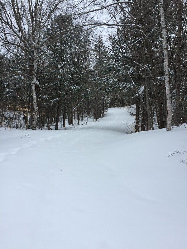
The Nanamacomuk begins on a USFS fire road.
 Untitled by Pinnah, on Flickr
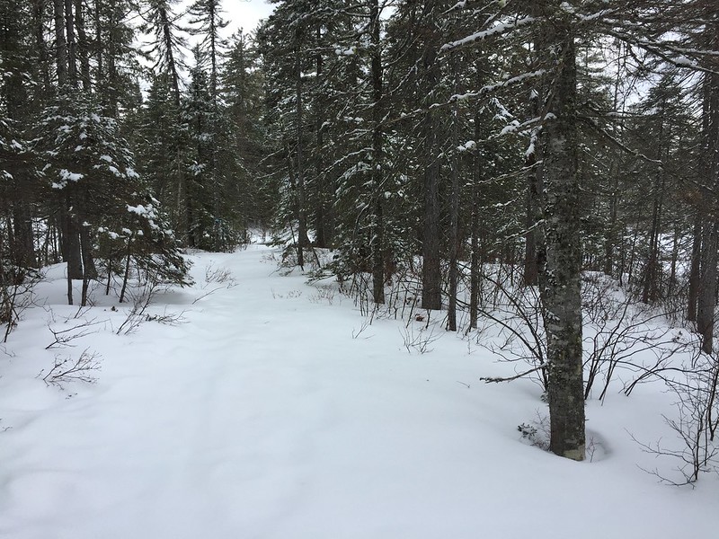
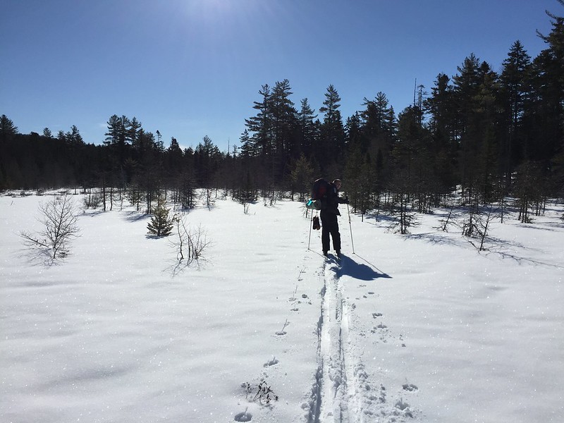
And then it drops down on a ski trail, which is also used by snowshoers. The elevation here is around 1500' which is just high enough to pick up boreal species like spruce, balsam fir and birch but still low enough to pick up large stands of white pine and hemlock.
 Untitled by Pinnah, on Flickr
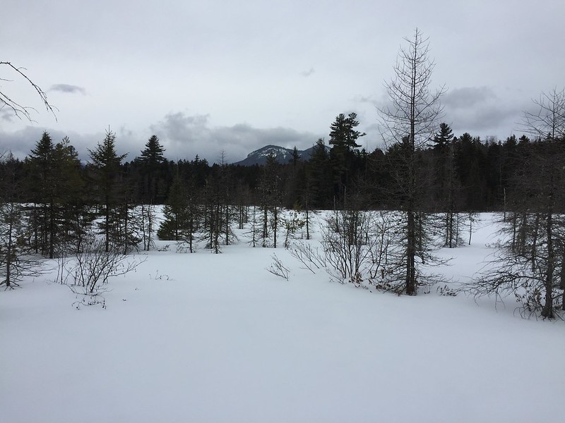
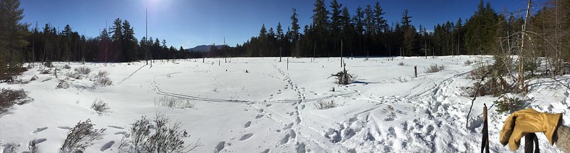
A short 2 miles in, we came to destination, a late stage "pond" which has moved into bog status and is starting to be reclaimed by the forest along the edges. With full snowpack, we could navigate across the bog without damaging it and here we found one of the first treats of the trip... a beautiful stand of Larch. Larch are coniferous trees that lose their needles every winter. They are sometimes found near our high ponds. The trees you see here are not dead. They've simply dropped their needles.
 Untitled by Pinnah, on Flickr
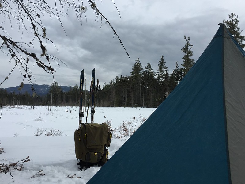
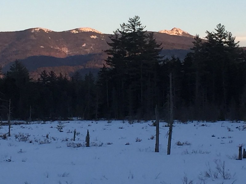
We followed some old moose tracks in the snow and worked our way around to the western end of the pond to be away from the trail and to be in position to catch the first warming rays of the sun in the morning. This gave us a lovely view of Mt. Chocora out our front door.
 Untitled by Pinnah, on Flickr
The tent we used was an old cheap knock-off of the floorless Megamid. Plenty of space for 2 for very little weight. The snow conditions were about 10" of wet corn snow on top of solid ice. I used an Opinel folding saw to cut 2' sections of some fir dead fall to create "dead man" anchors for the tent. We dug out trenches for the deadmen, looped line around them, buried the deadmen in their graves and stamped them down until the snow consolidated. The tent was then pulled into tension with a trucker's hitch. This would allow us to pull the lines free in the morning without needing to dig out the frozen in deadmen. It's a great technique for pitching a tent in the snow and it worked perfectly.
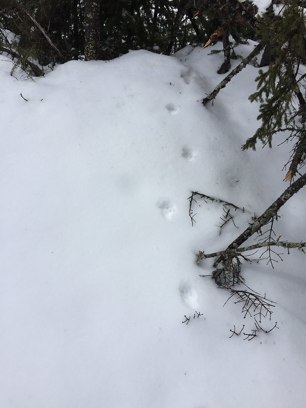
With camp set up, we skied back to the trail for an afternoon ski with lighter packs to see if we could make it out to the Swift River. Along the way, we saw several treats. This area has a large member of the weasel family called the fisher cat or, simply, the fisher. It's bigger than a pine marten but smaller than a wolverine. We didn't see the shy fisher but we found his tracks crossing our trail.
 Untitled by Pinnah, on Flickr
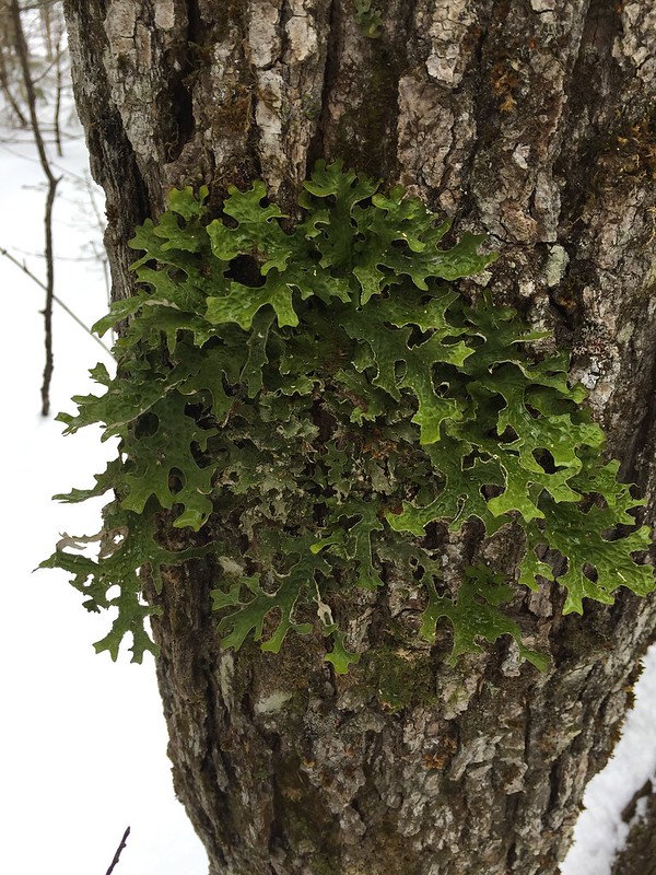
These a thick and magical woods. On the side of a tree, we found this.
 Untitled by Pinnah, on Flickr
These aren't oak leaves. This is a somewhat rare lichen called oak wurt or oak leaf lichen. It's crazy, right? It can only be found in places not damaged and with good air quality. There is a story of hope here. The trail we were on was flat - an abandoned railroad grade from the days when they used narrow gauge rail road to clear cut this area. The damage was so horrible and profound, we created the USFS to help manage our nation's forests and to prevent this sort of abuse. God's good Earth can recover if we work together to care for it.
Eventually, we made it to the Swift. Here, we could hear the occasional whir of a passing car on the road beyond the other bank. But we were cut off from that world by a moat of flowing liquid ice. There's no way to cross this river that doesn't end up with being soaked from the waist down.
 Untitled by Pinnah, on Flickr
We returned to camp under clearing skies and as expected, the temperatures quickly tumbled as the sun set behind us. But for a period of time, we were blessed with a nice alpenglow on Chocora.
 Untitled by Pinnah, on Flickr
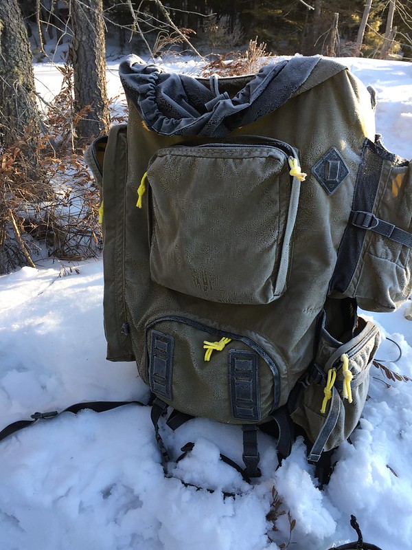
Did I say the temperatures tumbled? It was near 40F in the afternoon and a cool 8F in the morning when we decided to make breakfast. Cold winter fog was lifting off of the brook that ran through the pond/bog and the tent, trees and my pack had a nice coating of hoar frost.
 Untitled by Pinnah, on Flickr
But the sun - the glorious sun. The life giving grace of warmth from on high.
 Untitled by Pinnah, on Flickr
We skied out under bluebird skis on a bed of diamonds.
 Untitled by Pinnah, on Flickr
Winter in my neck of the woods has been fickle this year. The climate is changing and bringing new rhythms within the seasons. Luckily, a late season storm dropped a good amount of snow, making a spring ski trip a possibility.
New Hampshire's White Mountains are transacted by two east/west roads. The southern one is the Kancamagus Highway, which climbs out of the Pemigewasset River drainage, up over Kancamagus Pass and then down into the drainage of the Swift River. Between these two roads is the Pemigewasset Wilderness Area, which is surrounded by National Forest. We call the whole general area, "The Pemi".
The western half of the Kanc runs hand in hand with the Swift as it gathers size in it's run east to join the larger Saco River. On the north bank of the Swift, there is a XC ski trail called the Upper Nanamacomuk. This part of the region is generally flat higher elevation upland surrounded by higher peaks and marked by ponds, bogs and brooks. It's overlooked by hikers seeking the views of the peaks and in the winter becomes the playground for XC skiers and snowshoers.
The Nanamacomuk begins on a USFS fire road.
Untitled by Pinnah, on FlickrAnd then it drops down on a ski trail, which is also used by snowshoers. The elevation here is around 1500' which is just high enough to pick up boreal species like spruce, balsam fir and birch but still low enough to pick up large stands of white pine and hemlock.
Untitled by Pinnah, on FlickrA short 2 miles in, we came to destination, a late stage "pond" which has moved into bog status and is starting to be reclaimed by the forest along the edges. With full snowpack, we could navigate across the bog without damaging it and here we found one of the first treats of the trip... a beautiful stand of Larch. Larch are coniferous trees that lose their needles every winter. They are sometimes found near our high ponds. The trees you see here are not dead. They've simply dropped their needles.
Untitled by Pinnah, on FlickrWe followed some old moose tracks in the snow and worked our way around to the western end of the pond to be away from the trail and to be in position to catch the first warming rays of the sun in the morning. This gave us a lovely view of Mt. Chocora out our front door.
Untitled by Pinnah, on FlickrThe tent we used was an old cheap knock-off of the floorless Megamid. Plenty of space for 2 for very little weight. The snow conditions were about 10" of wet corn snow on top of solid ice. I used an Opinel folding saw to cut 2' sections of some fir dead fall to create "dead man" anchors for the tent. We dug out trenches for the deadmen, looped line around them, buried the deadmen in their graves and stamped them down until the snow consolidated. The tent was then pulled into tension with a trucker's hitch. This would allow us to pull the lines free in the morning without needing to dig out the frozen in deadmen. It's a great technique for pitching a tent in the snow and it worked perfectly.
With camp set up, we skied back to the trail for an afternoon ski with lighter packs to see if we could make it out to the Swift River. Along the way, we saw several treats. This area has a large member of the weasel family called the fisher cat or, simply, the fisher. It's bigger than a pine marten but smaller than a wolverine. We didn't see the shy fisher but we found his tracks crossing our trail.
Untitled by Pinnah, on FlickrThese a thick and magical woods. On the side of a tree, we found this.
Untitled by Pinnah, on FlickrThese aren't oak leaves. This is a somewhat rare lichen called oak wurt or oak leaf lichen. It's crazy, right? It can only be found in places not damaged and with good air quality. There is a story of hope here. The trail we were on was flat - an abandoned railroad grade from the days when they used narrow gauge rail road to clear cut this area. The damage was so horrible and profound, we created the USFS to help manage our nation's forests and to prevent this sort of abuse. God's good Earth can recover if we work together to care for it.
Eventually, we made it to the Swift. Here, we could hear the occasional whir of a passing car on the road beyond the other bank. But we were cut off from that world by a moat of flowing liquid ice. There's no way to cross this river that doesn't end up with being soaked from the waist down.
Untitled by Pinnah, on FlickrWe returned to camp under clearing skies and as expected, the temperatures quickly tumbled as the sun set behind us. But for a period of time, we were blessed with a nice alpenglow on Chocora.
Untitled by Pinnah, on FlickrDid I say the temperatures tumbled? It was near 40F in the afternoon and a cool 8F in the morning when we decided to make breakfast. Cold winter fog was lifting off of the brook that ran through the pond/bog and the tent, trees and my pack had a nice coating of hoar frost.
Untitled by Pinnah, on FlickrBut the sun - the glorious sun. The life giving grace of warmth from on high.
Untitled by Pinnah, on FlickrWe skied out under bluebird skis on a bed of diamonds.
Untitled by Pinnah, on Flickr