- Joined
- May 19, 2012
- Messages
- 2,265
I like to find special places most people would never encounter.
That's what drives me as well. It's a worthy mission

The BladeForums.com 2024 Traditional Knife is available! Price is $250 ea (shipped within CONUS).
Order here: https://www.bladeforums.com/help/2024-traditional/
I like to find special places most people would never encounter.
He had a knife, a lighter and some weed so he went back in the woods some from the road and found a nice spot and built a warm fire and got stoned and dozed till morning.

I do agree that these days a GPS is an obvious tool. Along with a map and compass. I use a Garmin 60 csx for ballooning and did for hiking, but my present phone is a better gps. It gets a fix onside my home (using just the gps receiver) whereas the garmin can not. It captures gps and glonass and I loaded it with ViewRanger hiking map software and a dirt cheap subscription to all topo maps of the national topo service, downloadable for offline use. Giving me all scales down to 1:25.000. With the maps stored on sd card it is a very good gps receiver that also happens to be a phone. I'm also pretty sure to have it on me during some non planned event. The Garmin eats AA cells as fast or worse as the phone its battery. But note that Android 8 and after save energy way better than older versions. As for ruggedness, I use a Crosscall ruggedized phone anyway. You can swim with it and probably throw it across the room. As a phone it is mediocre (apart from great reception of everything), as a GPS it is great. As everyone has a phone, I'd say at least load it with offline maps. You can get decent ones for free, even.Answering to the OP, I much rather walk out than spend the night there. If I need to spend the night, I would do the best I could with my gear and pray for the best. Headlamp with spare batteries and space blanket is mandatory gear in any pack.
I read through all posts and I would like to comment about the compass+map thing.
The compass allows you to align the map properly... but that's about it. Unless you know where you are or have good enough visibility + daylight to locate natural features which may help you (through triangulation, assuming you know how to do it) to find out where you are... you still will not know where you are. Which means, you cannot take any decissions based on that.
If you are stranded in the middle of the desert AND you know for a fact (or the maps tells you) that there is a road, river, train tracks or powerline runnign in a certain direction (and you are pretty sure that you are north/south/east/west of that particular "line" you could use the compass to make sure you walk in a straight line and find that reference. However, this only works in areas that allow you to walk in a semi-straight line. The mountains and forest areas are not like that. Terrain dictates where you can go.
It is important to know the basics but today, with so many handheld GPS devices meant for the outdoor, it is irresponsible not to use one when going into unknown terrain. And I reffer specifically to handheld GPS devices because using the phone for this particular use is akin to having all the eggs in the same basket. Phones are usually not as rugged as dedicated GPS devices, they eat up their battery much faster (and usually cannot be replaced on the spot, you need a battery bank), etc.
The GPS will tell you exactly where you are, even if you don't have any maps on it. And if you set it for tracking, it will store your way in from the starting point (line of dots taken each x seconds or every time you change your possition x meters). Some devices have a trackback feature, that allows you to go back over your steps (you don't even need a map for this). If it doesn't have it (I never use it), you just have to walk making sure to check the screen of the device often. If you are walking in trails, it is easy. If you are walking off trails it gets trickier. You need to be carefull when skiing or snowshoeing, because even if the tracks are visible, the track you made when going uphill might not be the most efficient/desired track to go downhill (tracing Z's uphill VS going down in semi straight line). Other than that, you are golden.
You can even take it one step further and download some tracks for free from Wikiloc in advance (from people who have done that route before and were so kind to upload them), check them in your computer and upload them to your device. This will let you reach peaks, huts, whatever even if you have never been there, with the worst visibility and while pitch black. Just follow the line (with common sense, of course).
I am not a full time pro climber, so I don't have time to waste one day investigating the aproach and retreat routes to my desired climbs. When I have the time, the conditions are good and my partner is motivated enough, I want to CLIMB.
Winter climbing (ice/snow) call for early starts (as 3am early I mean, even 00:30 in the Alps in spring/summer) to make sure the ice conditions are still good by the time you end up your climb and hike back to your car (this is not Alaska or Canada where the temps stay below freezing even in the sun for the whole day). If the snow/ice melts, rocks and ice start to fall, bad bad news. So, what do I do? I download a few tracks for that climb (or another one that I know share the approach route), dump them all at the same time in the PC, make sure they are all pretty much the same (do not rely on a single source) and then creat a single track. GPS software allows you to split and merge the tracks from different files. Maybe I use the approach from one file and the way back from another one. Then I load it in the GPS. And off I go.
For someone who just goes for a walk in the hills this might be overkill, but even if you don't download anything from Wikiloc, you could benefit from having the GPS device loaded with the maps of that area. They also give you information about water sources, huts, natural features, trails, etc. And if you screw up bad and need to navigate unknown terrain, it will let you know (through the elevation lines) if you are about to drop of a cliff or you are walking on flat terrain.
Summary, get a GPS, a headlamp and spare batteries for both. Space blanket also never hurts. I use an old (but fully functional) Garming GPSMap 62cs and Led Lenser H7.2R.
Mikel
....
Ultimately, if you go deep into the wild, bring a PLB emergency beacon. Activate it in case of real trouble and the rescue helo arrives before you know it. ;-)...
Not answering the question as such, but thought you might enjoy reading this article, since it seems to align with what folk here would do. It is written mainly with jungle in mind, but it is for the very situation that 22-rimfire describes.
https://bushcraftuk.com/survival-is-all-about-a-good-cup-of-tea/
I enjoyed that article. I am going to add a Cup O' Coffee component to my BOB now.
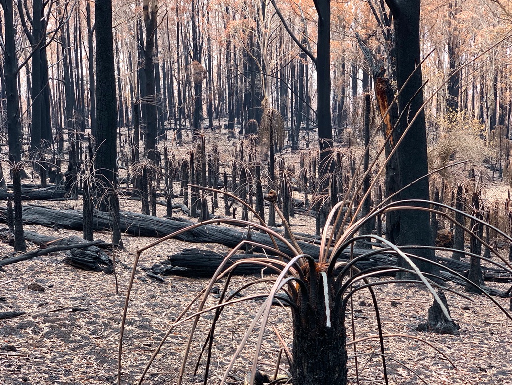
Currawong those are beautiful photos of some beautiful territory. Whereabouts?
I do agree that these days a GPS is an obvious tool. Along with a map and compass. I use a Garmin 60 csx for ballooning and did for hiking, but my present phone is a better gps. It gets a fix onside my home (using just the gps receiver) whereas the garmin can not. It captures gps and glonass and I loaded it with ViewRanger hiking map software and a dirt cheap subscription to all topo maps of the national topo service, downloadable for offline use. Giving me all scales down to 1:25.000. With the maps stored on sd card it is a very good gps receiver that also happens to be a phone. I'm also pretty sure to have it on me during some non planned event. The Garmin eats AA cells as fast or worse as the phone its battery. But note that Android 8 and after save energy way better than older versions. As for ruggedness, I use a Crosscall ruggedized phone anyway. You can swim with it and probably throw it across the room. As a phone it is mediocre (apart from great reception of everything), as a GPS it is great. As everyone has a phone, I'd say at least load it with offline maps. You can get decent ones for free, even.
Ultimately, if you go deep into the wild, bring a PLB emergency beacon. Activate it in case of real trouble and the rescue helo arrives before you know it. ;-)
I got temporarily lost a few times in the past before gps. A map, compass and triangulation do work to get unlost if you have visibility. Always carry the analog option as well...
That's sad. Nature's way....Monga National Park in New South Wales, Australia.
That whole area burnt during the recent bushfires and a lot of it looks like this now
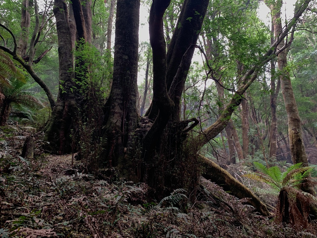
Though some of it survived